


Field Trip: Where are Those Quarries? Where is 26/27? What’s it All About?
By Peter Tollefsen, WAG member
It was a beautiful day of sunshine in early June when a number of Trust members gathered in the Walmart parking lot. There had been grumbling of late, “we don’t get out much” and “where the heck are all these quarries anyway.” So George Powell said, “I’ll show you. “And so a field trip was born.
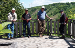
From left, WAG members Don Kerr, Duncan Bristow, George Powell and Blanka Guyatt at Devil’s Glen. Photo: Peter Tollefsen
We headed west on Mountain Road towards Scenic Caves and George pointed out a tributary of Silver Creek running along the road beside the new Windfall development. This watershed’s water quality is very good but development pressures are a major issue and concern.
Travelling up Scenic Caves Road we see the armouring of the ditches now in place that will help prevent erosion. Up on top of the Escarpment we stopped in at the scenic lookout at south hill (Blue Mountain resort parking lot) to take in the view of the Nottawasaga Lighthouse, the Bay and the Silver Creek wetlands. Just to the right is Cascade trail that descends along Townline Creek.
Then back in the car, continuing on, we went west on the 15th Sideroad, then south on 3rd Line and east on the 12th Concession slowing up at the brow to see where one of the tributaries of Silver Creek commences its descent into Castle Glen. After a scary drive to the bottom and south on Osler Bluff Road, we saw Silver Creek now flowing north towards Nottawasaga Bay.
Then back up the Escarpment again on County Rd 19 (I’m starting to get car sick). Then south at Castle Glen on the 2 nd Line and up even higher on a gravel road that kind of disappears at the dizzying knife edge of the mountain. (I’m praying we don’t meet a vehicle coming down). West on 6/7 Sideroad to see the existing pits in Gibraltar along with the new application area (expansion to the Conn pit for 150,000 tonnes per annum; area to be licensed 13.6 hectares; area to be extracted 10.7 hectares.) My, my!
Then driving south at a high rate of speed on the 4th Line. Then a right and a left toward Rob Roy (our navigator gave up). Then east on 31 and after the bend left on 26/27 screeching to a stop, on a narrow not much but a gravel pathway, at the escarpment brow.
We were now on the infamous 26/27, the centre of the fight. Presently it is closed in the
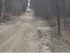
The narrow, no winter access road, 26/27 that runs through Escarpment Natural. Photo: George Powell
winter with signage that states, “Use at your own Risk”. Clearview proposes to widen the road to two lanes that would require extensive improvements to the drainage that would impact fish habitat and wetlands on the Escarpment and downstream. The Niagara Escarpment Commission turned down their application. Clearview appealed the decision and the matter is before a Tribunal with parties such as BMWTF and neighbours supporting the NEC. You could see the steep sides of Escarpment surrounding the small road now and imagine the devastating impact of having to excavate out all the forested terrain to put in a new wide roadway.
We bounced down to the bottom, went around the block, then back up again on 91 (from Duntroon) dodging gravel trucks and stopping over top of the tunnel connecting the existing Walker Quarry (on the south) and the new Walker Quarry on the right. The view down into the bottom of the new pit was startling. Then on to the top of the Escarpment to see the new St Mary’s and Osprey quarries. Welcome to “quarry junction.” Then we headed south to Singhampton with a stopover at the lookout at Devil’s Glen and finally home where the navigator/passengers could calm down with a quiet pint at a Collingwood pub.