Update on Townline Creek
By George Powell
The water quality of Townline Creek has been monitored since 2007 through a

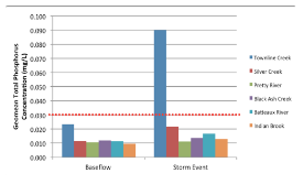
Figure 1: The geomean of total phosphorus concentrations (mgl/L) from the six Nottawasaga Bay watercourses originating on the Niagara Escarpment in 2015. Geomeans from stations closest to watercourse mouth.
WE KNOW THE POLLUTION SOURCES
Significant nutrient (TP) and suspended sediment inputs were observed at three locations along the Creek. At Gord Canning Drive, the Creek has descended the Escarpment receiving sediment and nutrient inputs from bare slopes, natural channel erosion, construction activities and roadside ditches. The cold, spring-fed headwaters quickly warm through this reach and become less desirable for coldwater fish species such as rainbow trout. The diversion of a coolwater tributary running along the west side of Scenic Cave Road to the Silver Creek watershed has also had detrimental impacts on the baseflow, temperature and water quality of Townline Creek.
Downstream of Gord Canning Drive, Townline Creek continues to receive inputs of sediment and nutrients from parking lots, roadside ditches, residential developments and the Monterra Golf Course. At Highway 26, flows are constricted by the culverts in the area creating a flooded backwater area extending upstream along Osler Bluffs Road and into the adjacent Silver Creek Wetland Complex.

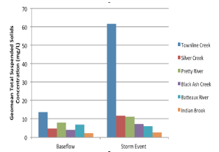
Figure 2: The geomean of total suspended solids concentrations (mg/L) from the six Nottawasaga Bay watercourses originating on the Niagara Escarpment in 2015. Townline Creek TSS objectives are depicted for informal purposes only. Each watercourse was compared to its own objective based on long term baseflow TSS concentrations.
During the spring freshet and rain events, discharges of sediment and nutrients from Townline Creek create a nearshore plume that extends into West Black Bass Bay – a bay that provides important wetland and spawning habitats utilized by a variety of fish species. TP concentrations within the plume in the Bay can exceed the lake-based Provincial Water Quality Objective of 0.02 mg/L; 30% of samples. Townline Creek is a small tributary, but for its size it carries a large nutrient and sediment load. The disproportionate loadings of Townline Creek into the Bay may be representative of the numerous small watercourses undergoing similar development pressure along the south shore of Georgian Bay.
To mitigate such impacts, greater attention needs to be given to sediment control during construction through a dual emphasis on minimizing the time in which soils are left bare and also on ensuring that temporary and permanent sediment control measures are properly selected for the site conditions (slope, storm intensity, etc.), properly installed and properly maintained. Other recommendations to improve the health of Townline Creek include naturalization of its stream bank areas. Innovative approaches to development, like Low Impact Development, are recommended.
Jurisdictional issues with respect to Townline Creek are complicated by the fact it lies on the border of Collingwood and the Town of Blue Mountains, and the Counties of Simcoe and Grey.
As well, the findings of this report need to be communicated to the various stakeholders so that there is a clear understanding of the impacts of development on the creeks that descend the Niagara Escarpment in the Blue Mountain area and the control measures needed to reduce this impact. A joint meeting with the various partners, agencies, individuals and ski hill operators is suggested as a way to move forward on addressing the impairments identified through this study.
Watershed Trust, the Town of The Blue Mountains Public Works and Planning staff and the Blue Mountain Resorts Operations and Management staff have met to discuss the findings of the 2015 report. We discussed erosion and sediment control relating to ski hill slumping and construction activities as well as the need for implementing Best Management Practices in this regard and regular monitoring and maintenance to ensure their proper function. Continued dialogue is recommended to minimize sediment/nutrient inputs to Townline Creek from ski hill operations.


