


Townline Creek Assessment Report for 2016
By George Powell, WAG member
The water quality of Townline Creek has been monitored since 2007 through a partnership of Blue Mountain Watershed Trust Foundation (BMWTF), the Nottawasaga Valley Conservation Authority (NVCA) and the Grey Sauble Conservation Authority (GSCA). The purpose of water quality monitoring is to identify potential impacts from existing and future developments in the Creek’s watershed and to provide recommendations towards mitigating identified impacts. Townline Creek is representative of the numerous small Escarpment watercourses that discharge directly into Nottawasaga Bay along its south shore. The sponsorship of Environment and Climate Change Canada started in 2014 and has allowed the study to continue to March of 2017.
Results from sampling (2007-2016) indicate that total phosphorus (TP) and total suspended solids (TSS) are parameters of concern in Townline Creek (see Figures 1 and 2 below).
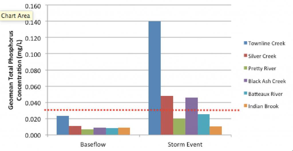
Figure 1: The geomean of total phosphorus concentrations (mg/L) from the six Nottawasaga Bay watercourses originating on the Niagara Escarpment in 2016. Geomeans from stations closest to watercourse mouth.
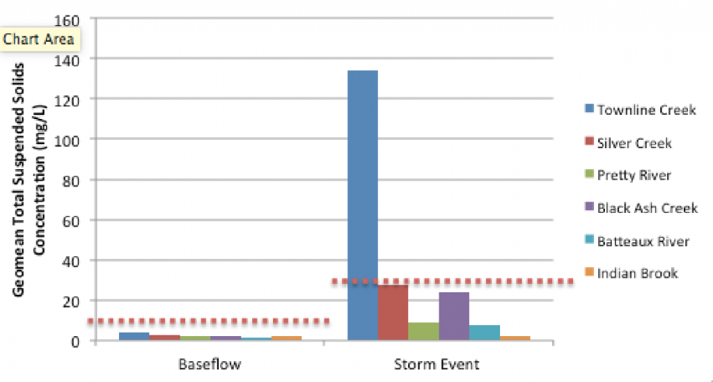
Figure 2: The geomean of total suspended solids concentrations (mg/L) from the six Nottawasaga Bay
watercourses originating on the Niagara Escarpment in 2016. Each watercourse was compared to its own
objective based on long-term baseflow TSS concentrations.
Benthic macroinvertebrate sampling, initiated in 2010, indicates that the benthic community diversity of Townline Creek is impaired. Beginning in 2009, monitoring was extended along the length of Townline Creek to identify pollution source areas. Significant nutrient (TP) and suspended sediment inputs were observed at three locations along the Creek. By Gord Canning Drive, the Creek has descended the Niagara Escarpment passing through the ski hill and facilities of Blue Mountain Resort receiving sediment and nutrient inputs from bare slopes, natural channel erosion, construction activities and roadside ditches.
The cold, spring-fed headwaters quickly warm through this reach and become less desirable for coldwater fish species such as rainbow trout. The diversion of a cool water tributary running along the west side of Scenic Cave Road to the Silver Creek watershed (circa 1980s) has also had detrimental impacts on the baseflow, temperature and water quality of Townline Creek.
Results throughout the study show that Townline Creek was warmer than Silver Creek with a temperature approaching the warm water threshold. This suggests significant thermal stress and marginal habitat for rainbow trout.
Downstream of Gord Canning Drive, sediment and nutrients associated with parking lots, roadside ditches, residential developments, infrastructure works and the Monterra Golf Course drain into the creek. At Highway 26, Townline Creek is constricted by the culverts in the area during storm and melt events, creating a flooded backwater area extending upstream along Osler Bluffs Road and into the adjacent Silver Creek Wetland Complex.
During the spring freshet and rain events, discharges of sediment and nutrients from Townline Creek create a near-shore plume that extends into West Black Bass Bay – a bay that provides important wetland and spawning habitats for a variety of fish species. TP concentrations within the plume in the Bay have been shown to exceed the lake-based Provincial Water Quality Objective of 0.02 mg/L. Compared to six other watercourses discharging into Nottawasaga Bay, Townline Creek consistently demonstrates degraded water quality with higher than average TP and TSS concentrations. The disproportionate loadings of Townline Creek into the Bay may be representative of the numerous small fringe Escarpment creeks undergoing similar development pressure along our area shores.
To mitigate observed impacts in Townline Creek and West Black Bass Bay it is recommended that greater attention be given to sediment control. Ski hill erosion and construction activity (commercial, residential and infrastructure) needs to be monitored and corrective action taken in a timely manner to minimize the time in which soils are left bare and to ensure that temporary and permanent sediment control measures are properly selected for the site conditions present (slope, soils, storm intensity, etc.), properly installed and properly maintained. Businesses and governments should be challenged to go beyond the minimum requirements to protect Townline Creek. The minimum is not working.
Other recommendations to improve the health of Townline Creek include naturalization of its shores and streambank and innovative approaches to storm water management in development areas. Jurisdictional issues with respect to Townline Creek are complicated by the fact it lies on the border of the Town of Collingwood and the Town of Blue Mountains, and the Counties of Simcoe and Grey. A well-understood and responsive communications plan is needed to address watershed concerns.
A higher level of sediment and erosion control monitoring is recommended to allow for faster corrective actions as part of development, infrastructure construction and maintenance activity. It has been documented that small watersheds, such as Townline Creek, are unable to maintain their health in the face of active recreational and urban development pressures. This former coldwater trout stream has been impacted to the point where it is marginal, at best, for rainbow trout. New, innovative methods of planning and development are required to ensure sustainable development and to protect our watercourses.
We would like to continue this study to include other fringe Bay creeks. There are more than 12 creeks exiting to the Bay. As well, flow monitoring and automatic sampling would greatly help to understand the impact of wet weather events. Finding funding and experienced staff is an issue for continuing this key activity. At this time BMWTF funding for this initiative is not budgeted.